Chester - Whitchurch. 36 miles
21st sept.2013
Today we cycled part of the Mercian Way. It runs from the Wyre forest to Chester through the former ancient Kingdom of Mercia, once ruled by the powerful Offa, the first man to claim the title of king of England. Special cast-iron way markers have been commissioned in the form of Anglo-Saxon warriors. Set up at strategic points along the trail, these soldiers will be on duty all year round to ensure that travellers can easily get their bearings.
We intended to cycle all the way to Shrewsbury, but found that it was too much. In fact we have decided to call it a day and go no further. The trip in 2011 was so different, seem to have much more energy and enthousiasm. We are making mistakes. The traffic is much worse. On the minor roads it,s ok but much hillier and also signs are missing. We both find that the fun has gone and are not truly enjoying it. We pretended for a while but have to be honest. We so much wanted to do this, the mind is willing, but both our bodies say 'stop'.
We may well have another go in 2014 as it seems a shame not to finish. There is only 1/3 to go and possibly in May we could try.
Sent from my iPad

Saturday, 21 September 2013
Friday, 20 September 2013
Croston - Chester 45 miles
Croston - Chester 45 miles
19th September 2013
It has been a really hard day. As the weather forecast was rain in the morning we did all the manoeuvring first. We drove the van to Frodsham. Took the train back to Croston. It still rained but we got on with it. We had lunch in the 'Robin Hood' and after which the rain had stopped. We took a B road to Dangerous Corner, on to Appley Bridge, Orrell then Haydock. On to Burtonwood road, across the M62 towards Sankey Bridges, through the Nature reserve on the Pennines cycle trail, cross over the River Mersey, the Manchester Ship canal, unfortunately on the congested A56 until we reached Frodsham again. After Haydock it was difficult. Signs were missing, and I am convinced a minor B road on the map was also missing as a fact. This does spoil the magic of cycling, especially with horizontal rain. Apart from that nothing very exciting happened. For this reason we are taking a day off and move the van to Shrewsbury, ready to take the train back in the morning. It should be good tomorrow as we will cycle the Mercian Way from Chester to Shrewsbury. Looking forward to it.
Sent from my iPad
Wednesday, 18 September 2013
Carnforth - Croston 48.18 miles
Carnforth - Croston 48.18 miles
Wednesday 18th September.
After 3 days of atrocious weather with storms and rain at times sideways, we decided we have to make the move. Carol, the beautiful weather girl on TV, who we have been listening to intently over the last days, said that Wednesday would be a better day. And so it was for most of the time. Straight away after arriving at Carnforth we took ourselves to the Lancaster canal, which has the no. 6 running alongside. What a treat this was. We had been looking forward to this and we weren't disappointed. North of Lancaster we crossed the viaduct and continued cycling next to the river Lune which then became the Lune Estuary. At Conder Green we turned right on to the Lancaster road, the A588, then the B5272 to Garstang. On to the B6430 to Catterall, the A6 to Broughton, the B6241 to Preston, crossing the River Ribble, on to the A582 to Leyland, B5253 to Moss Side, turn right on to the A581 to Croston, where we are staying.
We did have some showers and used the underneath of the canal bridge to shelter. That gives you the opportunity to have a chat with some of the locals, who are very generous with their advice. Although I always use my Philips Navigator, I did get it wrong in Preston. We usually look for other cyclists to ask -they always know-.
Well, the first day is over. Hope the weather will hold for tomorrow, so far it doesn't look very promising.
Sent from my iPad
Friday, 13 September 2013
The second half...
We will start cycling the second half of John O'Groats to Land's End on Sept 17th. Our starting point is Carnforth, the place we left off after the knee injury back in May this year. There is about 550 miles left to L.E. and our aim is to finish on Sept. 30th. We will see.
Saturday, 1 June 2013
Back home again and taking it easy. Just worked out that we have cycled just over half way - 561.54 miles to be exact and 520 miles left. We will do the other half next September. First get my knees back to normal. Won't take long.
On reflection the route we took in Scotland in 2011 was less hilly and more straight forward, however this years route was more beautiful and the scenery was awesome.
The point to make though is, that the only and most sensible way to do an End to End is to have support or be part of a team who will support you with all your luggage and organising. Most riders we met en route do just that. They carry nothing. They can then cycle of course 100 miles or so a day. Also, they often take the A roads which are dangerous, even more so with a heavy laden bike. So, to sum it all up it takes a lot of working out when you make a decision on the course you want to take. Any would be End to Enders read as much as possible on people's blogs in order to make your choice.
Sent from my iPad
Friday, 31 May 2013
Milnthorpe - Carnforth 10 miles
We decided this morning that the cycling was becoming too difficult for us. The hills are too steep for us with the panniers and the pressure on my knees is becoming painful with hill climbing after I had my fall last week. I don't want to ruin them, they have to last me.
Feel very upset about this decision. We have seen awesome scenery, met many fellow cyclists and had a good time. So, we are sorry folks, but that's life.
Sent from my iPad
Thursday, 30 May 2013
Hesket Newmarket - Milnthorpe 52.63 miles. Good weather, lots of hills.
We found out from our B&B hosts, that Hesket Newmarket is the village of Eddie Stobart, who is still alive and still lives in the village with other family members. There is now also Stobart Rail and Stobart Air. They purchased Carlisle airport and recently Southend Airport. A very big business has come out of a very small village.
We left quite early and stopped for refreshments at the very well known Mill Inn at Mungrisdale. The countryside has been absolutely stunning. fast open spaces with the hills around, it was awesome. We then reached the A66, forked off for the B5322, cycled the westside of Thirlmere, then on to the dreaded A591 through Grassmere, Ambleside, Windermere and to get off this dangerous fast road we changed to the NCN route 6. That was a good decision as we were constantly on safe cycle paths or country roads right up till Milnthorpe were we are staying. We must be halfway by now. Good!
Sent from my iPad
Wednesday, 29 May 2013
Lockerbie - Hesketh Newmarket 50.38 miles. Weather fine, except for 3/4 hour with light rain.
Lovely ride to Carlisle. In order to avoid heavy traffic near Carlisle we used NCN 74, 7, and 10 which took us without any hindrance to that part of Carlisle we intended to head for, which was the B5299 all the way to Hesketh Newmarket. But.....it was very hilly. Up till now we never walked a hill, but we or rather I succumbed. What a monster. Those cyclist we saw coming down must have clocked 50 miles ph.
A bit about Carlisle's history. Recent history has showed that Flemish textile workers emigrated to Britain in 1108 following disastrous floods in Holland, providing a foundation on which much of Britain's textile trade was built. Since medieval times, Carlisle has produced textiles, becoming the fourth most important cotton - producing area of the country in the early 1800s due to the special qualities of the river water used in the milling process. Scotsman William Linton started Linton Weaving Mill in 1912, choosing the name of Linton Cumberland Homespuns Ltd. The Linton company started its life in Shaddon Mill, the largest of its kind in the country, built in 1836 for Peter Dixon, a cotton merchant who came from Whitehaven. The mill's chimney rose above 300 feet, and is still one of Carlisle's landmarks and cycling through we didn't miss it.
We are staying in Hesketh Newmarket, a lovely village with a green and little shops around. As if time stood still here. All the properties look very well looked after, quite the opposite we have seen in other small villages. We are of course no longer in Scotland but back on English soil!
Sent from my iPad
Tuesday, 28 May 2013
Abington - Lockerbie. 40.2 miles. Still very cold, little sunshine, no rain.
We enjoyed the rest yesterday, also we missed the constant rain. When leaving this morning we were in good spirits again, had a lovely ride on the B7076 all the way to Lockerbie and mostly downhill. Abington is supposedly the highest village in Scotland, so no wonder we were exhausted from all that cycling uphill!
As we have never been to Lockerbie we wanted to take the chance this time to visit the Remembrance Garden. Here is a reminder of what happened. A bomb exploded on board Pan Am Flight 103, over Lockerbie, killing all 259 passengers and crew, together with 11 people on the ground. The design of the garden is quite beautiful in its simplicity and a large granite stone records all the names of those who lost their lives. There is also a visitor's centre and in their Dryfesdale Room is a large Commemorative Quilt on display. Again the quilt is dedicated to all who lost their lives in the events of 21 December 1988. The scene of the quilt is of the countryside with a tree in the foreground. The 259 leaves on the tree depict the souls who lost their lives. The 11 pebbles depict the residents of Lockerbie who lost their lives. The tree, underpinned by strong roots, represents the continuity of life, which reflects the way the people of Lockerbie and families of those who died, have striven to overcome this tragedy. The quilt was made as a remembrance of the twentieth anniversary of the disaster. The Town Hall in Lockerbie has a Memorial Window, depicting the flags of all the nations who lost citizens on that day. This year it will be the twenty fifth anniversary.
Sent from my iPad
Sunday, 26 May 2013
Glasgow - Abington 42.10 miles. Weather changeable and very cold.
Passed the time at Mac Donald's and left at 4 in the morning. Got straight on to the cycle path next to the river Clyde. It was a lovely ride, no one about and we made good progress. After this we got lost a few times. Signs had been smashed, over painted and turned around. The rest of the ride was uneventful. Of what we have seen, lanarkshire doesn't impress me. Wouldn't recommend it as the road surface was also rough and slows you down. We also feel very tired and a bit down. Knee is playing up a bit. We arrived very early at Abington and after this epistle we will sleep. May be stay an extra day. We will see. But......we are making progress.
Sent from my iPad
Crianlarich - Glasgow 64 miles. Lovely sunny day.
We had a lovely ride to Ardlui for our first half, mostly going down. Refreshments at Ardlui hotel, we have been there before and it is lovely. We then headed for Balloch, all the time cycling next to Loch Lomond. Beautiful views and on a cycle path, so quite safe. At Dumbarton we decided to go further as we were doing so well and arrived in Glasgow. So many hotels we wouldn' t have a problem we thought. Well, we have been in deep trouble.....
There was an important match between 2 german clubs I believe, then there was the cup final in Glasgow On Sunday, also a river race between Glasgow and Edinburgh, a road running race, bank holiday weekend...and every hotel room had been taken. Also, a home exhibition. We have tried every hotel in sight, went to the police station asking for help, but they too were unable to find us anything. Went back to the main railway station thinking to stay there in a waiting room till the morning. No way, they shut the place down at midnight. We ended up in a Mac Donald, drinking coffee!. The security man told us we could put the bike inside and sit there till 4 o'clock. That suits us fine we said, as it will be light then and we will go on our way again.
Very nice of them. We shall arrive a bit earlier tomorrow in Abington. We have booked a room there!
We look at it as a new experience....but feel foolish.
Sent from my iPad
Friday, 24 May 2013
Connell - Crianlarich 36.73 miles. On A85
Mostly sun. First half easy, second quite hard with some very long dragging hills. Also, the surface of the road was rough asphalt; it almost appears like a brake.
Stopped first for a break at Taynuilt. The second stop at the Cruachan Dam Visitor Centre. We were asked if we would like a guided tour and cyclists don't pay! But let me first tell you The Legend of Cruachan. So here goes:
The Cailleach Bheur or Bera (the old Hag of the Ridges), was the guardian of a fountain that welled up from the peak of Ben Cruachan. It was her duty to cover the spring with a slab of stone at sundown and lift away the rock at sunrise. One evening she fell asleep and the well overflowed. The water, rushing down the mountainside, burst open a new outlet to the sea through the Pass of Brander. By the time the Cailleach awoke, the water had flooded the wide strath below and drowned all the people and their cattle. So was formed the River Awe and Loch Awe. The Cailleach was turned to stone and sits to this day high on the mountain above the Pass of Brander.
Now for our tour.
We experienced an underground world on a spectacular scale. We were taken on a journey deep into the secret heart of this majestic mountain and were shown one of the hidden wonders of the Scottish Highlands - Cruachan Power Station. An underground hollow mountain and a place like no other. 1 km below the ground is a massive cavern, as high as the Tower of London, which houses enormous turbines converting the power of water from Loch Awe into electricity - sent straight to homes with the flick of a switch. A coach took us deep into the heart of this mountain, along a massive tunnel cut through solid rock. We were lead into a different world, so warm that sub- tropical plants grow due to the humid conditions. We were then shown the nerve centre of this station - the massive turbines are so powerful that they can create 100.000 kw of energy in only 2 min. It was an awesome visit and we all felt as if on set into a James Bond film.
After this we carried on cycling the 2nd half and arrived at Crianlarich at about 4.30.
Sent from my iPad
Thursday, 23 May 2013
Fort William - Connell. 42 miles.
A few spots of rain, some sun and very cold. Before we set off we went to a bike shop and had new brake pads fitted at the rear. Just to be on the safe site, as we have used them extensively down the hills. We had to set off again on the infamous dangerous A82 and met many cyclist going the other way. They all had big grins on their faces as they are getting nearer their goal. We stopped at Ballachulish for refreshments, then went on the A828 and were soon on a new cycle path(no.78) all the way to Connell. The cycling on the path was really good, it went through woods, past Loch Linnhe and the wind was in our favour, n.w. Having had a day off yesterday felt really beneficial. The room we have in the B&B tonight looks out on to Loch Etive. There is just a road between us and the water. Stunning view!
Connell is a small village and is in the area covered by Oban. Oban is the gateway to the western small isles and ferry services will take you to and fro. Some end to Enders use some of the isles to JOG.
p.s. I just want to mention the wonderful fish soup I had for lunch. Lovely!
Sent from my iPad
Wednesday, 22 May 2013
We decided to rest today :) we needed it.
A little more on Fort William, the 'Outdoor Capital of the UK'. 2013 is also the Year of Natural Scotland, celebrating their natural heritage. When looking at the shops in the centre of Fort William you see many outdoor Centre shops. Many of the hotels here have their own minibus to transport folk to and fro, often with knowledgeable local guide, which will enhance your experience. We visited the West Highland Museum and first watched a film about the Commando's Green berets; the elite Scottish Corps, set up by Winston Churchill after the defeat at Dunkirk. We saw how they were trained for 6 weeks before they were awarded their 'Green Beret'. Their training ground was at Achnacarry, west of the Great Glen Way. I believe only Scottish men could enlist in this corps, but I'm not quite sure on that.
Something else I found out was, that In 1896 Fort William became the first town in the UK to have electric street lighting entirely generated by water power. Some days ago we talked at a breakfast table to a guy, who was a surveyor in wave energy off the coast at Pentland Firth. He had installed equipment on the sea bed and that morning he was to collect the data - all done from a cabin on a boat! I used to believe that wind farming was the way forward, but have for some time now changed my mind. Certainly in Scotland with the many tidal waters and reading and listening to others, this must be it.
Sent from my iPad
Tuesday, 21 May 2013
Drumnadrochit - Fort William 51.08 miles.
No rain, little sun and still quite cold.
When leaving Drumnadrochit this morning, we left a really nice family, who had looked after us very well. Especially the young son, James, who after my mishap with the paving stone, gave me a cup of tea, biscuit and a cold flannel for my knee. He was a dear little boy.
So we set off again on the A82 towards Invermoriston with Loch Ness on our left, on to Fort Augustus, crossing the Caledonian canal and admiring the many locks. Still on the A82 we headed for the Bridge of Oich, Invergarry and stopped off at Letterfinlay for lunch while overlooking the beautiful Loch Lochy. Just before Spean Bridge we went to see the Commando Memorial and took a couple of pictures. Many folk were there, even coachloads of people. It is a category A-listed monument in Scotland and shows a large three-figure bronze statue. The Commando Association has since been disbanded but has been followed up by the Commando Veterans Association.
We reached Fort William at about 5.30 and feel quite tired. On reflection, the A82 is a dangerous road. We could have cycled The Great Glen Way on the opposite side but after all the rain the path would have been soft and the work would have been very hard with the panniers on the back. Especially Lionel's concentration has been very taxing for him, as he holds the controls. Some car drivers just don't give space and others like to use their horn, supposedly in support of our cycling effort. It is in actual fact unnerving. We are contemplating of having a rest day tomorrow.

Monday, 20 May 2013
Tain - Drumnadrochit 45 72 miles. Good weather.
Tain - Drumnadrochit 45 72 miles. Good weather.
We were given the advice to leave the A9 alone and so we did. Turned off at Arthurville and cycled cross country to Alness. What a lovely run this was. It is called the Aldie Burn. Stopped at Alness for refreshments and met up with an elderly lady cyclist, who was just amazing. From Alness on to Dingwall, albeit on the dreaded A9 for a little while. Then on to the A862 to Muir of Ord, Beauly. On to theA833 to Drumnadrochit. The last 10 miles were hell. Long dragging hills and at the end 2 descending hills, 15 %. That was very frightening but we arrived unscathed at the bottom. We looked for a B&B and as I was walking to someone's front door, I fell over a paving stone. Did not lift my feet properly. Two painful knees, bleeding finger with a bad cut and still not over the shock. All this way safely down this dangerous hill and messed up badly on a paving stone! Not a happy girl at present, but........the sun is shining.
Beauly was a lovely place with very nice shops. Drumnadrochit also, is a lovely small town on the shore of the famous Loch Ness.
We are going to have a meal overlooking the Loch and we have just arrived. We were collected by the Restaurant manager and he will take us back also. Part of the service for B&B's in Drumnadrochit.
Now sitting at the table overlooking the famous Loch Ness. Beautiful spot. Hope it will soften my knee pain.
Found out, that the restaurant and hotel has been named after John Cobb, the famous racing driver, who also made an attempt at the world water speed record on Loch Ness. He was the fastest man ever on the water but because he was killed instantly on his attempt, the record did not count.
Sent from my iPad
Sunday, 19 May 2013
Crask Inn - Tain 40.2 miles.
Early morning mist, sunny in Tain.
After a lively time in the breakfast room with church music in the background we really found this place unique and quite an experience, even though the accommodation was something I have no words for. And they are quite famous we now understand.
So off we went and continued on the A836 all the way to Tain. As we were very high up on the Scottish moors we had to put up with the mist and as we descended it gradually disappeared. Stopped at Shin Falls Visitors centre for refreshments :) Mohammed Al Fayed's place. Still a top class centre for a stop-off. The route was mainly easy and we had several short pit-stops.
Just finished a lovely Lamb curry and will now go back to our B&B.
A little about Tain. There is a little chapel nestling on the southern shore of the Dornoch Firth and which is the reputed birth place of St. Duthus. He made a significant impact on the history of Tain and the north of Scotland with his cult spreading north to Orkney and east to Aberdeen. Tain has also been made a Royal Borough, but I don't know when this happened. I will find it.
Sent from my iPad
Melvich - Crask inn, Saturday,18th May. No rain, but Scotch Mist the last hour.
Total mileage 44.06
We continued cycling on the A836 towards Bettyhill. Although it didn't rain we had to work so hard on the long hills, that we were soaked through from perspiration. Stopped at Bettyhill for refreshments and to dry out. We then had to face the hill going out of Bettyhill and life became a bit easier. Took the advice to take the route through the Strathnaver valley and that was quite do-able and lovely. At Altnaharra we met up with 4 other cyclists and spent an hour or so drinking tea in the Altnaharra hotel. We then carried on to the Crask Inn, where we are staying the night. It is a pub with rooms and they do meals. Well, you have never seen anything like it. Very friendly people, but the accommodation is from the year dot. Lionel said he wasn't even going to undress! When you look on the map you will see, that this Inn is in a very remote part of Scotland. It couldn't be more away from the real world then you can imagine. Yet the place is busy with a variety of all kinds of people. One cyclist, who had to do some washing, was told he could bring his wet gear to the bar and they would hang it out near the wood burner in the night! Well... I said they were friendly!
Just came back from the dining room and we have had a really lovely evening. The atmosphere is something we haven't encountered for a long time. The place is so bleak but it has something very special. Lots of people coming and going and we laughed a lot.
Approaching the Crask

 The Crask Inn
 Friday, 17 May 2013
Friday, 17th may. Mileage only 33.20, but it feels like 330! It was lovely weather to start with but it changed and had a nnw hitting us, which slowed us down. Also many long, long hills.
Left at 10 for the Castle of Mey - the Scottish castle, the Queen Mother purchased and had it restored to its former glory. We did a tour of the castle and the guide informed us with many details of the Queen Mother's likes and dislikes. We also looked and admired the walled garden. It is so lovely and sitting on her favourite bench, I felt like royalty myself! The castle overlooks Pentland Firth.
We continued our journey and arrived in Thurso at 1 o'clock. Thurso is the birthplace of Sir William Smith. He was the founder of the Boys Brigade. We cycled to Melvich in Scotch Mist and after our meal we will be heading to The Shielings in Melvich for our B&B.
We met several cyclist on the road. At Dunnet Bay was a group of cyclists coming towards us. Just a few miles for them to reach JOG. They can truly say: 'W've almost 'Dunnet'. They certainly had that look of glory, that it's almost over!
We get lots of waves from car drivers, who incidentally are very courteous.
Yesterday on the way to JOG we stopped at Carnisbay Kirk. This ancient church is the northernmost place of worship in the Scottish mainland. John o'Groats is buried here. They have moved his tombstone into the vestibule of the church for preservation. There is unusual lettering around the carved cross. It reads as follows: 'Donald Grot, sone to Johne Grot laid me heir April XIII day 1568 M.D.L. Lewys and Donald Grot and his gonaield lad and thaar faorbears of Donald whouse God cald me ye XIII day of April Anno Dominy MDL 1568".
Well, there is some ancient Gaelic for you to practice on!
This church was also used for worship by the Queen Mother and Prince Charles Duke of Rothesay worships here each year in August.


Thursday, 16th May. Mileage just 9.24 miles. Sunshine all day!
It has been an exciting but exhausting day. As our train to Thurso wouldn't leave till 11, the owner of the B&B where we stayed gave us a tour of Dingwall, telling and showing us all the historic places there. Once on the train we shared a table with a guy, who was following on a ordnance survey map exactly were the train was going. He has maps like that of the whole country! Quite a hobby! We exchanged some information with two fellow cyclists, that will be very useful later on in the journey.
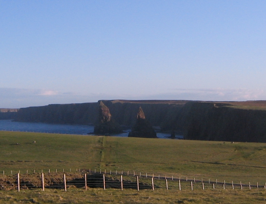
From Thurso we took a taxi to East Mey and soon after, our beloved tandem arrived - all put together as it should -. They gave an excellent service. On the train we saw other cyclists struggle with their bikes and were so glad we used this courier. After our evening meal we got on the bike to JOG and even cycled an extra 2 very hilly miles to see the Duncansby Lighthouse and the famous Duncansby stacks.
Always wanted to see those and to do that you actually have to walk on the top and edge of the U.K.! Tomorrow we will travel to Melvich, we are booked in there. But first we will go to visit the Castle of Mey.
Sent from my iPad


It has been an exciting but exhausting day. As our train to Thurso wouldn't leave till 11, the owner of the B&B where we stayed gave us a tour of Dingwall, telling and showing us all the historic places there. Once on the train we shared a table with a guy, who was following on a ordnance survey map exactly were the train was going. He has maps like that of the whole country! Quite a hobby! We exchanged some information with two fellow cyclists, that will be very useful later on in the journey.
From Thurso we took a taxi to East Mey and soon after, our beloved tandem arrived - all put together as it should -. They gave an excellent service. On the train we saw other cyclists struggle with their bikes and were so glad we used this courier. After our evening meal we got on the bike to JOG and even cycled an extra 2 very hilly miles to see the Duncansby Lighthouse and the famous Duncansby stacks.
Always wanted to see those and to do that you actually have to walk on the top and edge of the U.K.! Tomorrow we will travel to Melvich, we are booked in there. But first we will go to visit the Castle of Mey.
Sent from my iPad

Subscribe to:
Comments (Atom)